WaoLine The Internet Interactive and Dynamic General Visual Directory: premier visual portal on the web
Google
 
Web waoline.com

The NASA's Earth observation Missions

The Astronautic NASA's Earth Science Missions.

Open Menu
NASA Science Earth
EOSDIS
Heliophysics Science Division
Earth Sciences Division
GISS
Global Climate Change
IERS
CDDIS
VLBI
Sea Level
IDS, International DORIS Service
Aviso
SeaWinds QuikSCAT mission
MSFC-ESO
GHCC
Archeology
GDGPS
More classified links
NASA Science Earth banner
Image NASA: Magnetic field lines, collectively known as the magnetosphere, surround Earth
NASA Earth Science
Earth is a complex, dynamic system we do not yet fully understand. The Earth system, like the human body, comprises diverse components that interact in complex ways. We need to understand the Earth's atmosphere, lithosphere, hydrosphere, cryosphere, and biosphere as a single connected system. Our planet is changing on all spatial and temporal scales. The purpose of NASA's Earth science program is to develop a scientific understanding of Earth's system and its response to natural or human-induced changes, and to improve prediction of climate, weather, and natural hazards.

A major component of NASA's Earth Science Division is a coordinated series of satellite and airborne missions for long-term global observations of the land surface, biosphere, solid Earth, atmosphere, and oceans. This coordinated approach enables an improved understanding of the Earth as an integrated system. NASA is completing the development and launch of a set of Foundational missions, new Decadal Survey missions, and Climate Continuity missions." ... more
Space Earth Missions
ACRIMSAT - Aqua - Aquarius - Aura - CALIPSO - DISCOVER-AQ - Earth Observing-1 (NMP) - GOES I - M - GRACE - Jason-1 - LAGEOS 1&2 - Landsat 7 - NOAA-N - OSTM - QuikSCAT - SeaWinds - SORCE - Suomi NPP - Terra - TRMM

Under Study: CLARREO - DESDynI - ICESat-2      In Development: AirMOSS - ATTREX - CARVE - GOES N - P - GOES-R - GPM - HS3 - LDCM - NPOESS - OCO-2
EOSDIS logo
Image EOSDIS
EOSDIS
"The Earth Observing System Data and Information System (EOSDIS) is a key core capability in NASA's Earth Science Data Systems Program. It provides end-to-end capabilities for managing NASA's Earth science data from various sources - satellites, aircraft, field measurements, and various other programs. For the EOS satellite missions, EOSDIS provides capabilities for command and control, scheduling, data capture and initial (Level 0) processing. These capabilities, constituting the EOSDIS Mission Operations, are managed by the Earth Science Mission Operations (ESMO) Project. NASA network capabilities transport the data to the science operations facilities.

The remaining capabilities of EOSDIS constitute the EOSDIS Science Operations, which are managed by the Earth Science Data and Information System (ESDIS) Project. These capabilities include: generation of higher level (Level 1-4) science data products for EOS missions; archiving and distribution of data products from EOS and other satellite missions, as well as aircraft and field measurement campaigns. The EOSDIS science operations are performed within a distributed system of many interconnected nodes (Science Investigator-led Processing Systems and distributed, discipline-specific, Earth science data centers) with specific responsibilities for production, archiving, and distribution of Earth science data products. The distributed data centers serve a large and diverse user community (as indicated by EOSDIS performance metrics) by providing capabilities to search and access science data products and specialized services." ... more
ESPD - LASP - CloudSat - PPS - USGEO - Global Climate Change - USGS - GCMD - GES - GHRC - Mirador - NSIDC - Vertex
The Heliophysics Science Division banner
Image NASA, The Heliophysics Science Division
The Heliophysics Science Division
"The Heliophysics Science Division conducts research on the Sun, its extended solar-system environment (the heliosphere), and interactions of Earth, other planets, small bodies, and interstellar gas with the heliosphere. Division research also encompasses geospace -- Earth's uppermost atmosphere, the ionosphere, and the magnetosphere -- and the changing environmental conditions throughout the coupled heliosphere (solar system weather).

Scientists in the Heliophysics Science Division develop models, spacecraft missions and instruments, and systems to manage and disseminate heliophysical data. They interpret and evaluate data gathered from instruments, draw comparisons with computer simulations and theoretical models, and publish the results. The Division also conducts education and public outreach programs to communicate the excitement and social value of NASA heliophysics." ... more
Heliophysics Missions
ACE - AIM - CINDI/CNOFS - Cluster-II - BARREL (in development)
The Earth Sciences Division banner
Image NASA, The Earth Sciences Division
The Earth Sciences Division
"The Earth Sciences Division at NASA Goddard Space Flight Center plans, organizes, evaluates, and implements a broad program of research on our planet's natural systems and processes. Major focus areas include climate change, severe weather, the atmosphere, the oceans, sea ice and glaciers, and the land surface.

To study the planet from the unique perspective of space, the Earth Science Division develops and operates remote-sensing satellites and instruments. We analyze observational data from these spacecraft and make it available to the world's scientists. Our Education and Public Outreach efforts raise public awareness of the the Division's research and its benefits to society." ... more
Space Earth Missions
ACRIMSAT - Aqua - Aquarius - Aura - CALIPSO - DISCOVER-AQ - Earth Observing-1 (NMP) - GOES I - M - GRACE - Jason-1 - LAGEOS 1&2 - Landsat 7 - NOAA-N - OSTM - QuikSCAT - SeaWinds - SORCE - Suomi NPP - Terra - TRMM

Under Study: CLARREO - DESDynI - ICESat-2      In Development: AirMOSS - ATTREX - CARVE - GOES N - P - GOES-R - GPM - HS3 - LDCM - NPOESS - OCO-2
GISS banner
Image GISS
Goddard Institute for Space Studies
The NASA Goddard Institute for Space Studies (GISS) is a laboratory in the National Aeronautics and Space Administration's Goddard Space Flight Center's Earth Sciences Division, which is part of GSFC's Sciences and Exploration Directorate.

Following approval by NASA Administrator T. Keith Glennan in December 1960, the institute was established by Dr. Robert Jastrow in May 1961 as a New York City office of GSFC's Theoretical Division to do basic research in space sciences in support of Goddard programs. Much of the institute's early work involved study of planetary atmospheres using data collected by telescopes and space probes, and in time that led to GISS becoming a leading center of atmospheric modeling and of climate change.(...)

Current research at GISS, under the direction of Dr. James Hansen, emphasizes a broad study of Global Change, which is an interdisciplinary initiative addressing natural and man-made changes in our environment that occur on various time scales - from one-time forcings such as volcanic explosions, to seasonal/annual effects such as El Niño, and on up to the millennia of ice ages - and that affect the habitability of our planet.

A key objective of GISS research is prediction of atmospheric and climate changes in the 21st century. The research combines analysis of comprehensive global datasets with global models of atmospheric, land surface, and oceanic processes. Study of past climate change on Earth and of other planetary atmospheres serves as a useful tool in assessing our general understanding of the atmosphere and its evolution." ... more
Project Group
GACP - GCM - Glory - ISCCP
JPL - Global Climate Change banner
Image JPL - Global Climate Change
JPL - Global Climate Change, NASA's Eyes on the Earth
The Earth's climate has changed throughout history. Just in the last 650,000 years there have been seven cycles of glacial advance and retreat, with the abrupt end of the last ice age about 7,000 years ago marking the beginning of the modern climate era - and of human civilization. Most of these climate changes are attributed to very small variations in Earth's orbit that change the amount of solar energy our planet receives.

The current warming trend is of particular significance because most of it is very likely human-induced and proceeding at a rate that is unprecedented in the past 1,300 years.

Earth-orbiting satellites and other technological advances have enabled scientists to see the big picture, collecting many different types of information about our planet and its climate on a global scale. Studying these climate data collected over many years reveal the signals of a changing climate.

Certain facts about Earth's climate are not in dispute:
          . The heat-trapping nature of carbon dioxide and other gases was demonstrated in the mid-19th century.2 Their ability to affect the transfer of infrared energy through the atmosphere is the scientific basis of many JPL-designed instruments, such as AIRS. Increased levels of greenhouse gases must cause the Earth to warm in response.
          . Ice cores drawn from Greenland, Antarctica, and tropical mountain glaciers show that the Earth's climate responds to changes in solar output, in the Earth's orbit, and in greenhouse gas levels. They also show that in the past, large changes in climate have happened very quickly, geologically-speaking: in tens of years, not in millions or even thousands." ... more
Earth Science Missions
ACRIMSAT - Aqua - Aquarius - Aura - Calipso - CloudSat - Earth Observing-1 - LAGEOS 1&2 - Landsat 7 - QuikSCAT - SORCE - Terra - TRMM
The International Earth Rotation and Reference Systems Service
The IERS was established as the International Earth Rotation Service in 1987 by the International Astronomical Union and the International Union of Geodesy and Geophysics and it began operation on 1 January 1988. In 2003 it was renamed to International Earth Rotation and Reference Systems Service.

Measuring the irregularities of the Earth's rotation
The variability of the earth-rotation vector relative to the body of the planet or in inertial space is caused by the gravitational torque exerted by the Moon, Sun and planets, displacements of matter in different parts of the planet and other excitation mechanisms. The observed oscillations can be interpreted in terms of mantle elasticity, earth flattening, structure and properties of the core-mantle boundary, rheology of the core, underground water, oceanic variability, and atmospheric variability on time scales of weather or climate. The understanding of the coupling between the various layers of our planet is also a key aspect of this research.

Several space geodesy techniques contribute to the permanent monitoring of the earth's rotation by IERS. For all these techniques, the IERS applications are only one part of their contribution to the study of planet earth and of the rest of the universe." ... more
The Planetary Missions
Jason-1 - Jason-2 - TOPEX/Poseidon - GRACE
Goddard CDDIS banner
VLBI
The Crustal Dynamics Data Information System
"The Crustal Dynamics Data Information System (CDDIS) supports data archiving and distribution activities for the space geodesy and geodynamics community. The main objectives of the system are to store space geodesy and geodynamics related data products in a central data bank, to maintain information about the archival of these data, and to disseminate these data and information in a timely manner to NASA investigators and cooperating institutions. The CDDIS staff and computer facility are located at NASA GSFC in Greenbelt, MD and is part of the Solar System Exploration Division within the Sciences and Exploration Directorate. The CDDIS is funded by NASA's Earth System Science Data and Services (ESDIS).

The CDDIS has served as a global data center for the International GPS Service (IGS) since 1992. The CDDIS supports the International Laser Ranging Service (ILRS), the International VLBI Service for Geodesy and Astrometry (IVS), the DORIS Pilot Experiment, a precursor to the International DORIS Service (IDS), and the International Earth Rotation Service (IERS) as a global data center."... more
The Space Geodetic Techniques
GNSS - ILRS - VLBI - DORIS
Very Long Baseline Interferometry banner
Image VLBI
Very Long Baseline Interferometry
On the most basic level, Very Long Baseline Interferometry, or VLBI, is a geodetic technique that determines the positions of observing stations (sites) on the Earth by measuring the time it takes a radio wavefront from a quasar (source) to reach pairs of sites. For each pair, as the wavefront travels from the source at a constant rate in all directions, the front will arrive at each site at a different time, yielding differences in position, or distance, between the sites. As these distances are measured over time for a network of sites, site positions and position changes over time can be measured. Other factors must be applied to model complications in observing -- for example, changes in the atmosphere that slow the wavefront down.

The GSFC VLBI group studies the Earth and coordinates the international study of the Earth using the geodetic technique of VLBI. The GSFC VLBI group also supports general solar system exploration by providing data that missions (e.g., Cassini-Huygens and the Phoenix Mars Lander) use in calculating their flight paths." ... more
Sea Level banner
Image JPL - Global Climate Change
Sea Level, Science Objectives
Approaching 20 years of scientific discovery by NASA's ocean altimetry satellites has broadened the depth of science objectives for the missions. OSTM/Jason-2 and its successor missions are now expected to:Measure global sea-height change and provide a continuous view of changing global ocean surface topography:
          - Calculate the transport of heat, water mass, nutrients, and salt by the oceans
          - Increase understanding of ocean circulation and seasonal changes and how the general ocean circulation changes through time
          - Provide estimates of significant wave height and wind speeds over the ocean
          - Test how we compute ocean circulation caused by blowing winds
          - Improve the knowledge of ocean tides and develop open- ocean tide models
          - Improve forecasting of climatic events like El Niño and of global climate in general
          - Describe the nature of ocean dynamics and develop a global view of Earth's oceans
          - Monitor the variation of global mean sea level and its relation to global climate change" ... more
The Sea Missions
Jason-1 - Jason-2 - TOPEX/Poseidon - GRACE
IDS-DORIS logoThe Extreme Environment Chamber at NASA's Glenn Research Center Image credit: NASA
IDS, International DORIS Service
"DORIS (Doppler Orbitography and Radiopositioning Integrated by Satellite) is a Doppler satellite tracking system developped for precise orbit determination and precise ground location. It is onboard the Cryosat-2, Jason-1, Jason-2, ENVISAT and HY-2A altimetric satellites and the remote sensing satellites SPOT-4 and SPOT-5. It also flew with SPOT-2, SPOT-3 and TOPEX/POSEIDON.

IDS is an international service which provides a support, through DORIS data and products, to geodetic, geophysical, and other research and operational activities. New proposals for Analysis Centers and temporary or permanent DORIS stations are welcome. See the call for participation.

IDS, International DORIS Service site is composed of three parts:
"IDS" describes the organization of the service and includes documents, access to the data and products, event announcements, contacts and links.

"DORIS" allows to access general description of the system, and gives information about the system events and the tracking network.

"Analysis Coordination" provides information and discussion areas about the analysis strategies and models used in the IDS products. It includes also the information about the Combination Center activities. It is maintained by the Analysis Coordinator with the support of the Central Bureau."... more
IDS DORIS Satellites
Cryosat-2 - Jason-1 - Jason-2 - Envisat - HY-2A - Spot-4 - Spot-5
Image  Doris receiving antenna under the satellite. It receives signals from the terrestrial beacons network (its length is 42 cm). Credits Mira Productions.
Archiving, Validation and Interpretation of Satellite Oceanographic data (Aviso)
"With the satellite altimetry missions, the global mean sea level (GMSL) has been calculated on a continual basis since January 1993. 'Verification' phases, during which the satellites follow each other in close succession (Topex/Poseidon--Jason-1, then Jason-1--Jason-2), help to link up these different missions by precisely determining any bias between them. Envisat, ERS-1 and ERS-2 are also used, after being adjusted on these reference missions, in order to compute Mean Sea Level at high latitudes (higher than 66°N and S), and also to improve spatial resolution by combining all these missions together. In addition, permanent monitoring of quality during the missions (Calval) and studies of the necessary corrections of altimetry data regularly add to our understanding and knowledge (see the Processing and corrections applied to each mission to obtain the reference mean sea level)." ... more

The Doris system
"The Doris system is a french civil precise orbit determination and positioning system. It is based on the principle of the Doppler effect with a transmitting terrestrial beacons network and onboard instruments on the satellite's payload (antenna, radio receiver and oscillateur ultra-stable).
Doris is one of three systems used for precise determination of the Jason-1 satellite's orbit. Several of these techniques are sometimes merged on the same satellite : Jason-1 satellite includes three tracking systems, Doris, location by GPS and laser telemetry. The Doris system perfectly corresponds to the specifications required for the ocean's topography observations and the amplitude of the observed phenomena: it is now enables to measure the satellite position on its orbit close to 1 cm. It is interesting to compare this precision with the precision obtained at the beginning of the space age, where the the satellite position was estimated close to 20 km then close to 20 meters in the 80's. Since 1998, the Diode navigator has added real-time measurement processing capability for satellite navigation." ... more
Sea level Satellites Missions
Jason-1 - Jason-2 - Spot - Cryosat-2
NASA logo
SeaWinds QuikSCAT image at JPL
The SeaWinds QuikSCAT mission
"The SeaWinds on QuikSCAT mission is a "quick recovery" mission to fill the gap created by the loss of data from the NASA Scatterometer (NSCAT), when the satellite it was flying on lost power in June 1997. The SeaWinds instrument on the QuikSCAT satellite is a specialized microwave radar that measures near-surface wind speed and direction under all weather and cloud conditions over Earth's oceans.

SeaWinds uses a rotating dish antenna with two spot beams that sweep in a circular pattern. The antenna radiates microwave pulses at a frequency of 13.4 gigahertz across broad regions on Earth's surface. The instrument will collect data over ocean, land, and ice in a continuous, 1,800-kilometer-wide band, making approximately 400,000 measurements and covering 90% of Earth's surface in one day."... more
The SeaWinds missions
NSCAT - QuikSCAT - ADEOS II
Marshall Space Flight Center Earth Science Office Banner
Image MSFC-ESO
The Marshall Space Flight Center - Earth Science Office

"The Marshall Space Flight Center Earth Science Office provide integrated scientific understanding of the Earth system to enable better decisions improving the global quality of life.

The ESO's many areas of study are closely related to each other. Like the climate and environment study, no one aspect stands alone. Water vapor, winds, temperatures at different altitudes, lightning, aerosols, and other factors all connect in a complex, interactive Earth-atmosphere system. This is what makes our work both challenging and intriguing. The best way to grapple with so many questions is by scientists teaming across different disciplines and organizations. ESO scientists collaborate closely with other research centers, both in the United States and in other nations. ESO work also to spread awareness and understanding of our results among leaders and citizens of today and the future." ... more
NASA logoBanner GHCC
Image Lightning Imaging Sensor (LIS)
The GHCC Lightning Team
"Within the Global Hydrology and Climate Center (GHCC), there is a group of researchers, mostly scientists and engineers, who collectively form the GHCC Lightning Team. As part of their research activities, the members of this team have been investigating the causes and effects of lightning as well as analyzing a wide variety of atmospheric measurements related to thunderstorms.

One of the primary objectives of this group is to determine the relationship between the electrical characteristics of storms and precipitation, convection, and severe weather. In order to achieve this objective, the GHCC Lightning Team has designed, constructed and deployed numerous types of ground based, airborne, and space based sensors used to detect lightning and characterize the electrical behavior of thunderstorms.

Space Research and Observations
Space based sensors can provide us with literally several times more data than ground based sensors. Most ground based and airborne sensors are only capable of detecting cloud to ground lightning, which is known to make up only about 25% of total lighting activity. This is further limited by the facts that ground sensors can only detect activity over land, and airborne sensors have a limited observation time. Thus, with these sensors alone, we are incapable of studying lightning activity over the two-thirds of the earth that is covered by ocean.

A space based sensor can detect lightning activity over land and sea, 24 hours a day, and can detect all forms of lightning. Thus, such sensors will allow the development of the first global database of lightning activity. Such information can be used for severe storm detection and analysis, and lightning-atmosphere interaction studies."... more
Space based sensors
Lightning Imaging Sensor - Optical Transient Detector - Lightning Mapper Sensor - Defense Meteorological Satellite
MSFC Archeology banner
Image MSFC Earth Science Office: Archeology
Archeology Program at NASA MFSC Earth Science Office
"Much of human history can be traced through the impacts of human actions upon the environment. The use of remote sensing technology offers the archeologist the opportunity to detect these impacts which are often invisible to the naked eye. This information can be used to address issues in human settlement, environmental interaction, and climate change. Archeologists want to know how ancient people successfully adapted to their environment and what factors may have led to their collapse or disappearance. Did they overextend the capacity of their landscape, causing destructive environmental effects which led to their demise? Can this information be applied to modern day societies so that the mistakes of the past are not repeated?

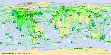
Remote sensing can be used as a methodological procedure for detecting, inventorying, and prioritizing surface and shallow-depth archeological information in a rapid, accurate, and quantified manner. Man is a tropical creature who has invaded every environment on earth successfully; now we are ready to explore, and eventually colonize, the delicate environments of Space. Understanding how ancient man successfully managed Earth is important for the success of current and future societies.

"The stereotype has archaeologists just digging up spearheads and pottery and anthropologists just writing down the words of primitive tribes. But we're examining how people adapted to their environment throughout time, how they experienced environmental shift, why cultures come and go. Soils associated with artifacts are as important as the artifacts themselves--probably more relevant to us than the actual objects. Now more than ever, archaeological research is interdisciplinary: botany, forestry, soil science, hydrology--all of which contribute to a more complete understanding of the earth, climatic shifts, and how people adapt to large regions. This understanding is critical to future decision making affecting the planet.

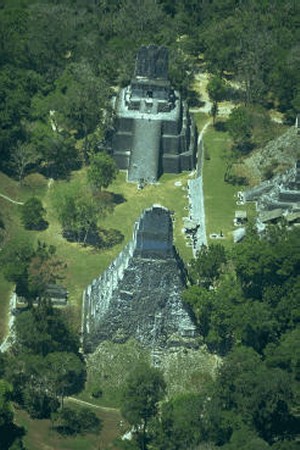
In Costa Rica, the culture survived repeated volcanic explosions that repeatedly destroyed the environment, explosions equal to the force of a nuclear blast. Other cultures, like the advanced Maya societies, did not survive or recover from similar eruptions. Did it have to do with the size and violence of the eruption, the way they farmed their land over time, or territorial and political struggle?"
more
GDGPS banner
Image JPL - GDGPS
The NASA Global Differential GPS (GDGPS) System
The NASA Global Differential GPS (GDGPS) System was developed at the Jet Propulsion Laboratory (JPL) in support of NASA's demanding terrestrial, airborne, and spaceborne operations, and for other Government and commercial customers. JPL is a Division of the California Institute of Technology (Caltech), which manages the laboratory for NASA. JPL is NASA's lead center for robotic exploration of space, and is responsible for technology development and operations of many NASA missions and infrastructure.

With nearly 60 GPS engineers and scientists working in this field, JPL is one of the biggest GPS and GNSS R&D laboratories in the world, with an unparalleled track record of innovations and leadership in GPS technology and its advanced applications. End-to-end GPS expertise includes: systems, software, hardware, infrastructure, flight experiments, operations, and science

The GDGPS System is managed and operated in the Tracking Systems and Applications Section of JPL's Telecommunications Division." ... more
Clic for your Research of books on Amazone about: Space
Amazone : Astrophysic - Astronautic - Astronomy - Space Astronomy
Directories : Yahoo: Science - Space - News and Media
MSN: Space News - Demoz: Science - Space - News and Media - Astronomy
CSS Valide !CSS Valide !
Copyright WaoLine, The Internet Interactive and Dynamic Visual Directory